All components in place for potential Central African-style copper mineralization
Highlights
- Several large, near-surface conductors representing potentially reductive permeable stratigraphy favourable to host sediment-hosted copper mineralization delineated by airborne MobileMT geophysical survey
- New sampling verifies historical occurrences, including Payback Showing (up to 61.2% copper (Cu) with 5,600 grams per tonne (g/t) silver (Ag)) and CBC Showing (up to 9.9% Cu, 1.9% lead (Pb), 3.5 g/t gold (Au) and 431 g/t Ag)
- Multiple new copper, zinc and lead occurrences were discovered across the property in 2024 sampling, along with locally anomalous gold, silver and cobalt
- Additional mineral claims staked on prospective ground expanding claim block by 11,608 hectares (ha) to a total of 102,108 ha (1,002 square kilometres (km2))
Aston Bay Holdings Ltd. (TSXV:BAY) (OTCQB:ATBHF) (Aston Bay or the Company) is pleased to report on sampling, mapping and geophysical programs at the Epworth Project (Epworth or the Project) in Nunavut.
Thomas Ullrich, Chief Executive Officer of Aston Bay, commented:
Analysis of the 2024 exploration programs at Epworth is delivering exciting results pointing to the potential for large-scale copper mineralization at the property.
The surface sampling programs have confirmed previous work where large boulders yielding up to 61.2% copper with 5,600 g/t silver were found at the surface along with several other zones of high-grade metal mineralization. With significant lead, zinc, gold and anomalous cobalt in several newly discovered areas on this large property, we have only scratched the surface.
These are excellent results, but with mineralization typically confined to structurally controlled fracture filling (veins), building significant tonnage of mineralized material can be challenging. The widespread nature of the metal mineralization, however, points to the potential for large-scale stratigraphically-controlled mineralization at depth this is the sediment-hosted copper deposit model used to find the large copper deposits of Central Africa and successfully used at our other project, Storm Copper.
Of the key components required to form an extensive sediment-hosted copper system, the discovery of these conductors provides the final piece of the puzzle at Epworth: these conductors may represent the reductant, in the form of pyrite or graphite in a permeable horizon, that forces the precipitation of metals over large areas within this stratigraphic unit and bounding faults. The first interaction of metal-bearing fluids with a reductant is the site of metal sulfide deposition in this model, providing a large target of potential metal accumulation. As well, the conductors may represent some metal sulfide mineralization themselves.
These are compelling targets tens of kilometres in scale, mostly within 300m from the surface. We continue to work with the data to refine optimal drill targets for a potential drill program later this season.
MobileMT Survey Summary
In late summer 2024, a property-wide airborne MobileMT (Mobile MagnetoTelluric) geophysical survey was completed at the Epworth Project in Nunavut. The survey, conducted by Expert Geophysical Systems, covered 8,105 line-kilometres across the entire extant claim block, with 100-metre line spacing in the northern half and 200-metre spacing in the southern half to ensure high-resolution data over priority areas.
The MobileMT system utilizes naturally occurring electromagnetic fields generated by global lightning activity. By measuring both magnetic and electric field variations, the system provides high-resolution geoelectrical data from the surface to depths exceeding one kilometre. This allows for the detection of resistivity contrasts associated with geological structures, alteration zones, and potential mineralized bodies in any orientation.
Preliminary Results Apparent Conductivity
The purpose of the survey was mapping of bedrock structures and lithology, including possible alteration and mineralization zones reflected in the electrical and magnetic properties of rocks. The airborne geophysical survey results are presented as apparent conductivity corresponding to different frequencies, resistivity-depth profiles determined from inverting EM data, available VLF EM data, as well as magnetic field data and its derivatives.
Inversion of the data yielded a 3D voxel representation of apparent conductivity that is dominated by extensive conductive bodies spatially associated with the southern portion of the Proterozoic Recluse Group rocks, a sedimentary succession of sandstones and carbonate rocks (Figures 1 through 3). Formations comprising the group are locally pyritic and graphitic, both potential reductants for metal-bearing fluids, and coarsen to the south, potentially increasing permeability and porosity for metal deposition. Three cross-sections through the more conductive southern portion of the claim block (Figure 1) show the higher conductivity bodies extending from near-surface, dominantly to approximately 300m depth, extending locally to 900m at the western fault contact.
It is postulated that the apparent conductivity reflects the pyrite or graphite in the Recluse Group rocks, and that these rocks may act as a potential trap for metal-bearing fluids. The stronger conductivity to in the southern portion of the claim block may even represent metal sulfide accumulation in the more porous southern Recluse rocks.
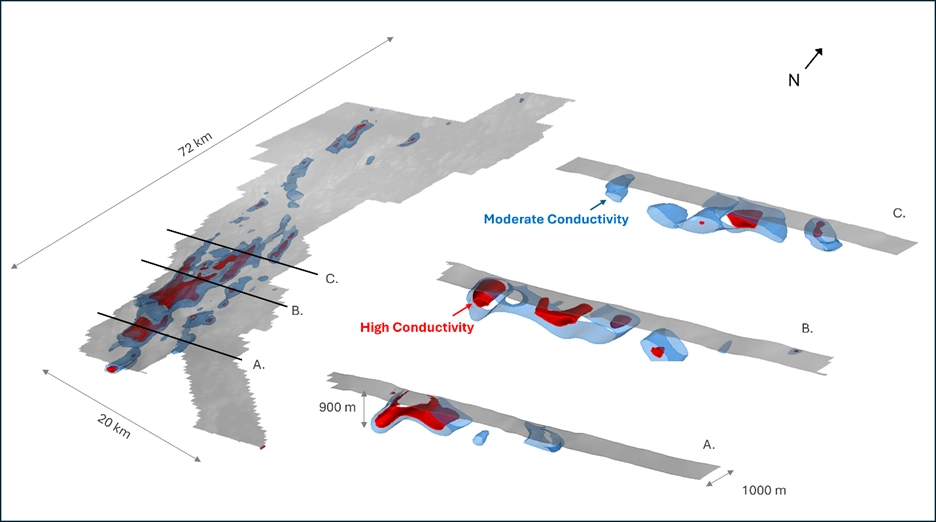
Figure 1: Oblique and cross-sectional views of 3D inversion results from the MobileMT survey looking down towards the northwest, highlighting extensive target conductive bodies at depth at the Epworth project. The red and blue shapes represent resistivity iso-surfaces at 1100 and 1390 ohm-m, respectively.
Frequency in electromagnetic surveys, such as MobileMT, controls for depth of investigation, with lower frequencies penetrating deeper into the ground, making the apparent conductivity measurement more representative for deeper layers. Higher frequencies are more sensitive to shallow subsurface features, as their electromagnetic fields attenuate more rapidly with depth.
Deeper apparent conductivity anomalies may represent the stratigraphic targets at Epworth, while shallow apparent conductors may represent the structural/fault-controlled mineralization at the surface. Figure 2A shows an excellent spatial coincidence of the deeper, low-frequency conductor (42 Hz, blue and white colours) with the Recluse Group. Surface mineralization at the historic at-surface Metallic (northern showings) and CBC (southeastern showings) shows a correlation with shallower, high-frequency conductors (453 -8550 Hz, green to red colours). In addition, examination of the derivatives (i.e., abruptness of change in the conductivity, Figure 2B) show a good correlation to known surficial mineralization, likely associated with mineralization along vertical structures and faults. Future exploration will examine the potential of other, near-surface conductors.
Although the stratigraphic target represented by the deeper apparent conductor presents the more immediate compelling target, mineralization taking advantage of structural corridors also remains a valid target for further exploration.
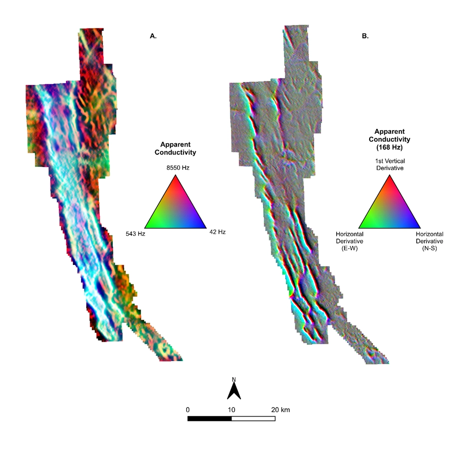
Figure 2: Plan maps showing custom composite gridded images from the MobileMT survey.
A. Grid composite image for three frequencies of apparent conductivity that highlights conductors that are close to or at surface in red and brown, and those that extend from near surface to depth in white and blue. The deeper (while/blue) conductors appear confined to the sedimentary rocks of the Recluse Group.
B. Grid composite image of 168 Hz and its vertical and horizontal derivatives to highlight conductors, whether strong or weak, detected at this frequency, highlighting shallow conductors.
A program is underway to integrate all results with new geological mapping, rock and lake sediment sampling, and historical geophysical data to generate and prioritize targets for follow-up exploration and potential drilling in 2025. This work is ongoing, with additional analyses and reports expected over the coming weeks.
Permits are in hand for the first phase of modern drilling in the northern claim area; work is underway to modify the permitted locations for the new targets in the southern claim block.
New Staking and 2024 Field Program
The 2024 Epworth exploration program took place from July 15th to August 18th, based out of four fly-camps on four separate lakes, targeting numerous prospective areas on the property. An inflatable boat was used to facilitate travel from campsites and collect lake sediment samples. Nine additional claims, adding an additional 11,900 ha of ground, were staked during the program, and, after the field program and motivated by the Mobile MT geophysical program results, an additional 11,608 hectares were staked in June 2025 (Figure 3).
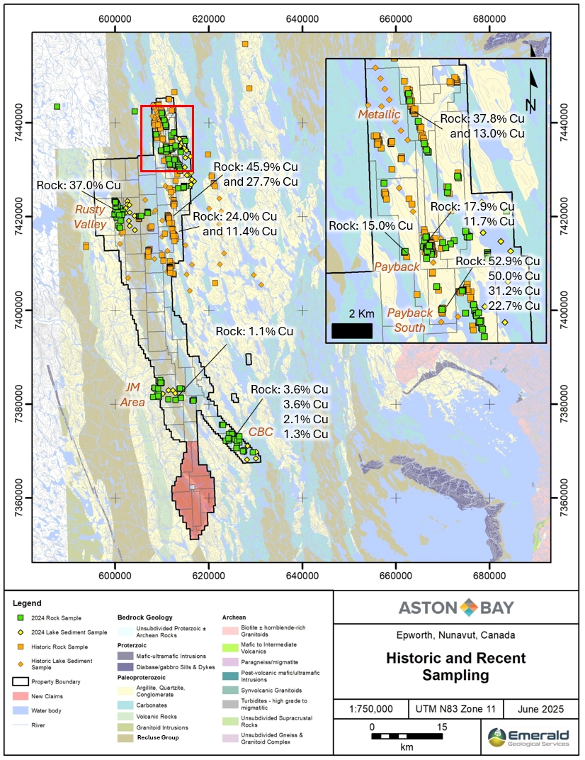
Figure 3: Recent claim staking (red shaded area) and significant copper grab sample assays from 2024 and historic programs. Inset map area denoted by red bounding box.
A total of 362 rock grab samples and 34 lake sediment samples were collected on the current claims during the program. A summary of significant results is presented below (Figure 3). Rock grab sample results maps are presented by element (Cu, Zn, Pb, Co, Ag, Au) and Lake sediment sample results maps, separated by precious metals and base metals, are available on the Aston Bay website.
Payback Metallic South Area
The Payback trend, towards the northern end of the current property, was historically targeted by Noranda Exploration in the 1990s.
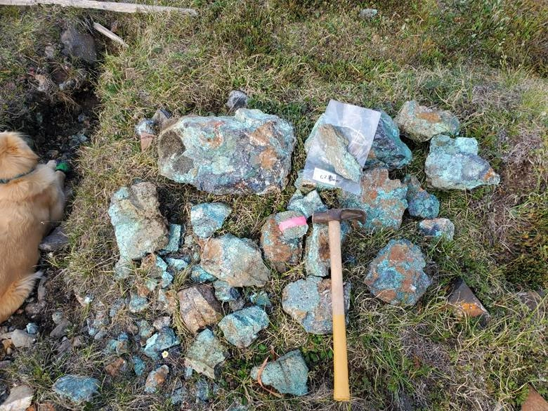
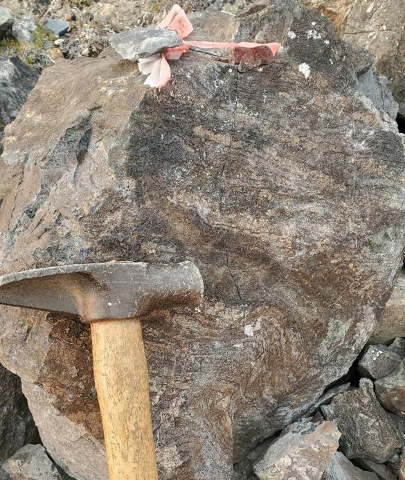
At the historical Payback South showing, boulders which previously returned up to 61.2% Cu with 5,600 g/t Ag were located and re-sampled during the 2024 program, returning up to 52.9% Cu, up to 3,880 g/t Ag, and up to 233 ppb Au. The boulders, along with numerous similar rock chips, are located in a series of frost boils on the flank of a diabase dyke. They are composed largely of massive bornite or chalcocite with quartz.
Payback South boulders, looking east.
At the historical Payback North showing, located approximately 3 km north-northwest of Payback South, mineralized zones were located and sampled during the 2024 program, and historical drill pad sites were located. Noranda drilled two very shallow holes there, totalling 99.5 meters, with one of the holes returning 0.3% Cu over 8.3 meters, from dolomite with microfracture-hosted chalcocite. 2024 rock grab samples along the drilled horizon returned up to 17.9% Cu, with 14 grab samples returning >1% Cu along a strike length of 225 meters, open to the north and south.
Approximately 1.5 km across strike to the east of the Payback Trend, a 1.3 km Zn-Pb trend was identified in 2023, subparallel to the Payback Trend, with Zn results up to 16.2% and Pb results up to 2.8%, as sphalerite-galena stringers or blebs in a dolomite horizon in outcrop. The anomalous trend was extended to the south in 2024, for a total length of 2.2 km. New samples along the southern extension returned up to 4.8% Zn and 3.0% Pb. This area may represent the southern strike extension of the horizon(s) hosting the Metallic Trend, 9 km to the north-northwest. The Metallic Trend is a 1.1 km trend of high-grade mineralization which yielded grab sample results up to 37.8% Cu, 27.4% Zn, 19% Pb, 3 g/t Au, 1,130 g/t Ag, and 1700 ppm Co from 2021-2022. From over 300 total historic rock grab samples, 51 samples yielded over 1% Cu, 29 samples yielded over 30 g/t Ag, and 15 samples yielded over 1% Zn.
Rusty Valley Area (NW Claims)
The Rusty Valley area is located in the northwestern part of the Epworth property. The 2024 field program targeted base metal anomalies in historical lake sediment samples and copper values up to 2.5% in historical grab samples, collected by Noranda.
A prominent gossan zone on the western flank of a >100-meter-wide valley was identified during the 2024 program. Mineralization consists mainly of pyrite within black shale, but zinc anomalies up to 1.13% Zn were also obtained. An angular boulder of a strongly silica-altered rock also returned a gold value of 535 parts per billion (ppb) Au. The mineralized zone, open to the east within the valley, is associated with a prominent conductive trend that runs down the propertys west side for 62 km.
Gossan zone at Rusty Valley, looking north
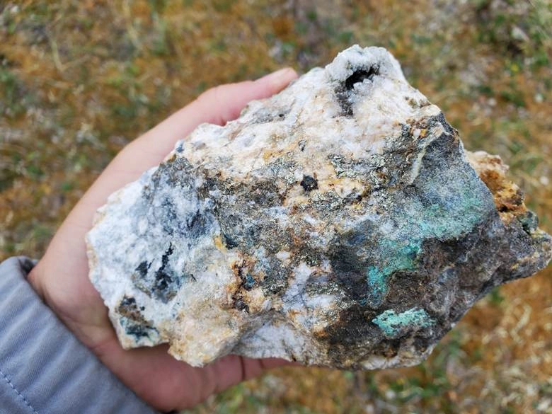
Approximately 300 meters west of the gossan zone, a horizon of dolomite was located hosting chalcopyrite stringers sporadically across a width of at least 20 meters (named the Slope Showing). Grab samples of this mineralization in outcrop or frost heave returned up to 4.03% Cu. A composite sample of frost-heaved, malachite-stained rock chips on the west side of the dolomite outcrop, close to the contact with grey shale to the west, returned 37.0% Cu.
Chalcopyrite-rich vein in dolomite at Slope Showing

The dolomite unit was traced at least 2 km further to the north, where samples of frost heave returned up to 9.15% Zn, up to 11.7% Pb, and up to 150 ppb Au.
A further 300 meters across strike to the west of the dolomite unit, base metal mineralization was located in angular boulders of brecciated clastic metasediments with quartz veining and gabbro outcrop with calcite stringers. These returned up to 3.4% Cu, up to 2.3% Zn, up to 0.8% Pb, and up to 337 ppb Au.
Quartz vein with chalcopyrite, malachite staining from brecciated clastic metasediments
850 meters south-southwest of the previous area, subcrop of shale with chalcopyrite-bearing quartz veining was sampled, returning up to 2.0% Cu.
All of the above mineralization is believed to be newly discovered. However, two clusters of historical Noranda samples are located approximately 800 meters and 3.1 km south-southeast of the last-mentioned area, with past results of up to 2.5% and 2.4% Cu, respectively. 2024 sampling in these areas returned up to 2.1% Cu in the first area, and 0.9% Cu with 157 ppb Au in the second area.
Anomalous mineralization in the Rusty Valley area has been identified along a strike length of approximately 5.7 km. The findings from the 2024 program indicate a much broader mineralizing system than previously recognized in this area, with multiple subparallel mineralized zones in shale, dolomite and mafic dykes.
JM Area (SW Claims)
Prospecting and sampling was carried out in the southwestern portion of the property close to the western property boundary and near Norandas historical JM showing, which returned past results up to 6.8% Zn and 0.25% Pb, from dolomite with disseminated sphalerite and galena. This style of mineralization was not located during the 2024 program; however, gossanous quartz veins up to 0.8 m thick in the area returned up to 2.9% Zn.
A new copper showing was identified 2.7 km west of the JM showing, returning up to 1.1% Cu (with 92 ppb Au) from dolomite with chalcopyrite and chalcocite stringers in outcrop. The showing occurs on the east side of a stream valley which flows into a lake to the north, where one of the four program campsites was located. This lake yielded the programs best Cu and Zn Lake sediment sample anomalies, 133 ppm Cu and 300 ppm Zn.
CBC Area
Prospecting and sampling were carried out in the southeastern limb of the property near the historical CBC Showing, where a cluster of angular boulders in a valley returned past results of up to 9.9% Cu, 1.9% Pb, 3.5 g/t Au and 431 g/t Ag, hosted in organic-rich dolomite. The boulders were located in the 2024 program and re-sampled, with results of up to 3.6% Cu, up to 485 ppb Au, up to 2.3% Pb, and up to 205 ppm Ag.
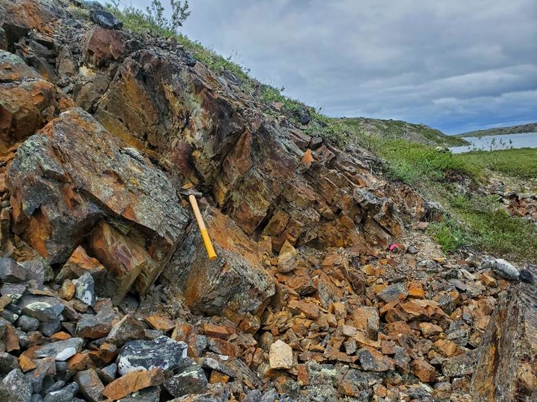
Historical flagged sample of organic-rich dolomite boulder at CBC Showing
160 m south-southeast of the main cluster of boulders, a mineralized outcrop on the west side of the target valley returned 0.54% Cu, 11.3% Zn, 11.5% Pb, 157 ppb Au, 128 ppm Ag, and 161 ppm Co, hosted in fractured dolomite with >5% disseminated sulphides.
3 km further to the south-southeast, a cluster of angular boulders with base metal mineralization was located on an island in the lake south of the showing. These boulders returned up to 2.0% Cu, up to 317 ppb Au, up to 358 ppm Ag, up to 4.2% Zn, and up to 7.4% Pb. Mineralization is hosted mainly within white quartz veinlets in dolomite.
750 meters north of the lake, dolomite with several thin (100mt) high-grade (3-4% Cu) sediment-hosted stratiform copper deposits.
History and recent work
The Epworth Project was explored by Noranda Mining and Exploration in the mid-1990s, resulting in the discovery of new base metal showings. Chalcocite boulders at surface yield up to 61.2% Cu with 5600 g/t Ag in select rock grab samples. Prospecting, mapping, geophysics and sparse drilling (only 132m in the original claim block,